Restaurant nearby Kam Mun
Guatemala
Restaurant nearby Kam Mun
Kam Mun
Cobán, Guatemala
contacts phone
:
+502 7952 1109
Latitude:
15.4704224
, Longitude:
-90.3794334
larger map & directions
read more
nearest Restaurant
75 m
Comidas Doña Flory
Cobán
Restaurant
read more
99 m
Tropikuba
2da calle, 8, 24, coban
Restaurant
read more
121 m
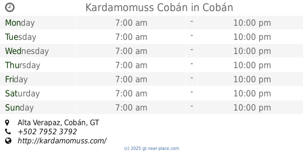
Kardamomuss Cobán
3a Calle 8-11, Alta Verapaz, Cobán
Restaurant
read more
137 m
COMIDA DE LA ABUELITA
10a Avenida, Cobán
Restaurant
read more
184 m
La Parrillada, Churrascos
2-11 Cobán, 11 Avenida, Guatemala
Restaurant
read more
265 m
Sahil Wa
1a Calle 5-27, Cobán
Restaurant
read more
282 m
Sedano`s Steakhouse
Cobán
Restaurant
read more
364 m
El peñascal
Cobán
Restaurant
read more
421 m
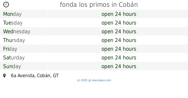
fonda los primos
6a Avenida, Cobán
Restaurant
read more
455 m
La Lonchera Coban
1a Calle, Cobán
Restaurant
read more
490 m
Delicias Chipi-Chipi
2da calle 14-47, Cobán
Restaurant
read more
499 m
Cafe y vinos
Cobán
Restaurant
read more
543 m
Casa D'Acuna
Cobán
Restaurant
read more
544 m
Restaurante Camil
11 avenida, 3-14, Coban
Restaurant
read more
556 m
Pollo Granjero
1a Calle, Cobán
Restaurant
read more
571 m
La Casa Del Monjes
4a Avenida, Cobán
Restaurant
read more
600 m
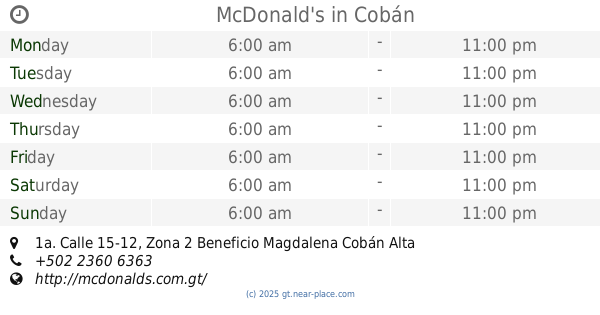
McDonald's
1a. Calle 15-12, Zona 2 Beneficio Magdalena Cobán Alta Verapaz, Cobán
Restaurant
read more
616 m
Delipanes
1a calle 15-47, Cobán
Restaurant
read more
687 m
La Abuelita
Cobán
Restaurant
read more
696 m
Taco Bell
Cobán
Restaurant
read more
756 m
Panificadora Verapan
3A Calle, Cobán
Restaurant
read more
819 m
Pollo Campero
Cobán
Restaurant
read more
879 m
Kleaple Koban
2a Calle, Cobán
Restaurant
read more
973 m
La Abadia
1a Calle, Cobán
Restaurant
read more
984 m
Cevichería D'CARCAMOS
2-36, 1a Calle 6, Cobán
Restaurant
read more
📑
all categories
Accounting
Administrative area level 1
Administrative area level 2
Airport
Amusement park
Aquarium
Art gallery
Atm
Bakery
Bank
Bar
Beauty salon
Bicycle store
Book store
Bowling alley
Bus station
Cafe
Campground
Car dealer
Car rental
Car repair
Car wash
Casino
Cemetery
Church
City hall
Clothing store
Colloquial area
Convenience store
Courthouse
Dentist
Department store
Doctor
Electrician
Electronics store
Embassy
Establishment
Finance
Fire station
Florist
Food
Funeral home
Furniture store
Gas station
General contractor
Grocery or supermarket
Gym
Hair care
Hardware store
Health
Hindu Temple
Home goods store
Hospital
Insurance agency
Jewelry store
Laundry
Lawyer
Library
Liquor store
Local government office
Locality
Locksmith
Lodging
Meal delivery
Meal takeaway
Mosque
Movie rental
Movie theater
Moving company
Museum
Natural feature
Neighborhood
Night club
Painter
Park
Parking
Pet store
Pharmacy
Physiotherapist
Place of worship
Plumber
Point of interest
Police
Political
Post office
Premise
Real estate agency
Restaurant
Route
Rv park, camping
School
Shoe store
Shopping mall
Spa
Stadium
Storage
Store
Subway station
Supermarket
Synagogue
Taxi stand
Train station
Transit station
Travel agency
University
Veterinary care
Zoo
administrative area level 3
sublocality level 1
↑