Park nearby Parque Edmundo Nanne
Guatemala
Park nearby Parque Edmundo Nanne
Parque Edmundo Nanne
7A Avenida, Guatemala Gwatemala
contacts phone
:
+502
Latitude:
14.6094837
, Longitude:
-90.5087895
read more
nearest Park
547 m
Jardín Manuel Ayau
6A Calle, Guatemala
Park
read more
547 m
Manuel Ayau Garden
6A Calle, Guatemala
Park
read more
608 m
Parque Ciudad Vieja
Zona 10
Park
read more
730 m
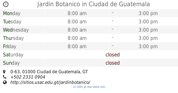
Jardin Botanico
Avenida La Reforma, 0-63, Guatemala
Park
read more
970 m
Parque
Zona 15
Park
read more
1.1 km
Plaza Confucio
Guatemala
Park
read more
1.1 km
Plaza Confucio
Guatemala City
Park
read more
1.139 km
Parque San Pedrito
Zona 5
Park
read more
1.146 km
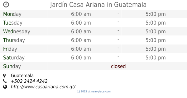
Jardín Casa Ariana
Guatemala
Park
read more
1.146 km
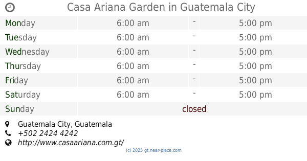
Casa Ariana Garden
Guatemala City
Park
read more
1.252 km
Plaza de la Republica
Guatemala
Park
read more
1.252 km
Plaza de la Republica
Guatemala City
Park
read more
1.254 km
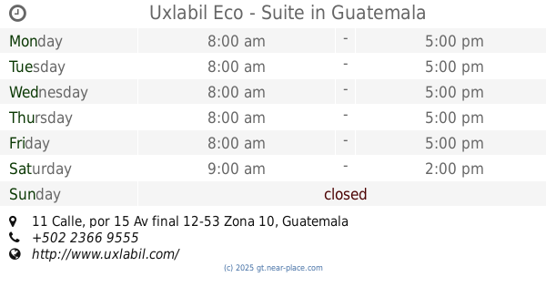
Eco Suites Uxlabil Guatemala City
11 Calle, por 15 Av final 12-53 Zona 10, Guatemala
Park
read more
1.254 km
Uxlabil Eco - Suite
11 Calle, por 15 Av final 12-53 Zona 10, Guatemala
Park
read more
1.414 km
La Marimba
Zona 15
Park
read more
1.728 km
Monumento Olimpico
Guatemala
Park
read more
1.728 km
Monumento Olimpico
Guatemala City
Park
read more
1.74 km
Parque ViviBien
Guatemala
Park
read more
1.74 km
Parque ViviBien
Gwatemala
Park
read more
1.821 km
Mom and Tots
Plaza Obelisco, 1-01 16 Calle 10
Park
read more
1.897 km
Parque Ecológico y Deportivo Cayalá
Diagonal 29 02-00, Calzada la Paz, Guatemala
Park
read more
1.906 km
Plaza del Obelisco
Guatemala
Park
read more
1.977 km
Obelisco Guatemala
Guatemala City
Park
read more
2.092 km
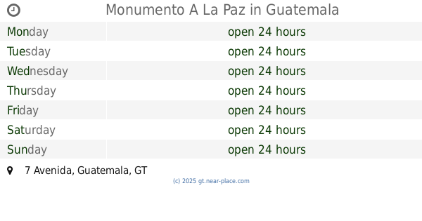
Monumento A La Paz
7 Avenida, Guatemala
Park
read more
2.165 km
Los Arcos Sports
Avenida Las Americas 1-03, Guatemala
Park
read more
📑
all categories
Accounting
Administrative area level 1
Administrative area level 2
Airport
Amusement park
Aquarium
Art gallery
Atm
Bakery
Bank
Bar
Beauty salon
Bicycle store
Book store
Bowling alley
Bus station
Cafe
Campground
Car dealer
Car rental
Car repair
Car wash
Casino
Cemetery
Church
City hall
Clothing store
Colloquial area
Convenience store
Courthouse
Dentist
Department store
Doctor
Electrician
Electronics store
Embassy
Establishment
Finance
Fire station
Florist
Food
Funeral home
Furniture store
Gas station
General contractor
Grocery or supermarket
Gym
Hair care
Hardware store
Health
Hindu Temple
Home goods store
Hospital
Insurance agency
Jewelry store
Laundry
Lawyer
Library
Liquor store
Local government office
Locality
Locksmith
Lodging
Meal delivery
Meal takeaway
Mosque
Movie rental
Movie theater
Moving company
Museum
Natural feature
Neighborhood
Night club
Painter
Park
Parking
Pet store
Pharmacy
Physiotherapist
Place of worship
Plumber
Point of interest
Police
Political
Post office
Premise
Real estate agency
Restaurant
Route
Rv park, camping
School
Shoe store
Shopping mall
Spa
Stadium
Storage
Store
Subway station
Supermarket
Synagogue
Taxi stand
Train station
Transit station
Travel agency
University
Veterinary care
Zoo
administrative area level 3
sublocality level 1
↑