Park nearby Lagunas de San Miguel
Guatemala
Park nearby Lagunas de San Miguel
Lagunas de San Miguel
San Juan Sacatepéquez Guatemala
contacts phone
:
+502
Latitude:
14.7726423
, Longitude:
-90.6280382
read more
nearest Park
3.506 km
Parque De San Raymundo, Guatemala
San Raymundo
Park
read more
12.068 km
Jardín De Eventos Agusto
Guatemala
Park
read more
12.068 km
Eventos Agusto Garden
Guatemala City
Park
read more
13.061 km
parque infantil
Zona 5 de Mixco
Park
read more
13.099 km
Area Verde Residenciales El Encino
Guatemala City
Park
read more
14.549 km
El Zanjón, Paseo De Los Campeones
Bulevar San Nicolas, Guatemala
Park
read more
15.472 km
Área Verde del Condado Naranjo
Gwatemala
Park
read more
15.472 km
Área Verde del Condado Naranjo
Guatemala
Park
read more
15.472 km
Área Verde del Condado Naranjo
Guatemala-Stadt
Park
read more
16.444 km
los pinos Park
Colonia el Amparo, Guatemala City
Park
read more
16.979 km
Campo De Futbol Bethania
Guatemala City
Park
read more
17.533 km
Erick Barrondo Park
Guatemala City
Park
read more
17.59 km
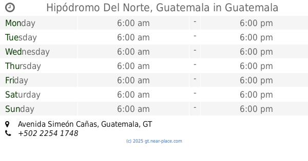
Hipódromo Del Norte, Guatemala
Avenida Simeón Cañas, Guatemala
Park
read more
17.732 km
Parque Minerva
Guatemala
Park
read more
18.033 km
La Floresta Park
Guatemala City
Park
read more
18.033 km
Parque La Floresta
Guatemala
Park
read more
18.365 km
Morazán Park
Guatemala City
Park
read more
18.655 km
José Batres Montufar
Zona 1
Park
read more
18.718 km
San Sebastián Park
3A Calle 5-26, Guatemala
Park
read more
18.802 km
Parque Isabela Católica
Gwatemala
Park
read more
18.802 km
Parque Isabela Católica
Guatemala
Park
read more
18.981 km
Parque Centenario
Guatemala City
Park
read more
19.677 km
Parque La Navitividad
Guatemala
Park
read more
19.677 km
La Navitividad Park
Guatemala City
Park
read more
20.36 km
Monumento a la Madre
Guatemala City
Park
read more
📑
all categories
Accounting
Administrative area level 1
Administrative area level 2
Airport
Amusement park
Aquarium
Art gallery
Atm
Bakery
Bank
Bar
Beauty salon
Bicycle store
Book store
Bowling alley
Bus station
Cafe
Campground
Car dealer
Car rental
Car repair
Car wash
Casino
Cemetery
Church
City hall
Clothing store
Colloquial area
Convenience store
Courthouse
Dentist
Department store
Doctor
Electrician
Electronics store
Embassy
Establishment
Finance
Fire station
Florist
Food
Funeral home
Furniture store
Gas station
General contractor
Grocery or supermarket
Gym
Hair care
Hardware store
Health
Hindu Temple
Home goods store
Hospital
Insurance agency
Jewelry store
Laundry
Lawyer
Library
Liquor store
Local government office
Locality
Locksmith
Lodging
Meal delivery
Meal takeaway
Mosque
Movie rental
Movie theater
Moving company
Museum
Natural feature
Neighborhood
Night club
Painter
Park
Parking
Pet store
Pharmacy
Physiotherapist
Place of worship
Plumber
Point of interest
Police
Political
Post office
Premise
Real estate agency
Restaurant
Route
Rv park, camping
School
Shoe store
Shopping mall
Spa
Stadium
Storage
Store
Subway station
Supermarket
Synagogue
Taxi stand
Train station
Transit station
Travel agency
University
Veterinary care
Zoo
administrative area level 3
sublocality level 1
↑