Lodging nearby Parqueo Velorio
Coronavirus disease (COVID-19) Situation
confirmed cases
1291293
deaths
20289
Guatemala
Lodging nearby Parqueo Velorio
Parqueo Velorio
Centro Histórico de Guatemala, Guatemala
contacts phone
:
+502
Latitude:
14.6381162
, Longitude:
-90.51336
larger map & directions
read more
nearest Lodging
171 m
Maya Excelsior
7A Avenida, Guatemala
Lodging
read more
260 m
Hotel Royal Palace
6ta Avenida 12-66, Guatemala
Lodging
read more
347 m
Hotel Centenario
Guatemala
Lodging
read more
347 m
Hotel Centenario
Guatemala City
Lodging
read more
348 m
Hostal Centro Historico
Guatemala City Historical District, Guatemala City
Lodging
read more
382 m
Hotel Ejecutivo Reforma I
11 Calle, Guatemala
Lodging
read more
438 m
Pensión Meza
Guatemala
Lodging
read more
465 m
Pasaje De La Inmaculada Y Gomar
6 avenida A 14-47, Guatemala
Lodging
read more
468 m
HOTEL POSADA OSLO
Centro Histórico de Guatemala, Guatemala
Lodging
read more
521 m
Hotel Centenario
6A Calle 5-33, Guatemala
Lodging
read more
604 m
Hotel Belmont
9A Avenida, Guatemala
Lodging
read more
635 m
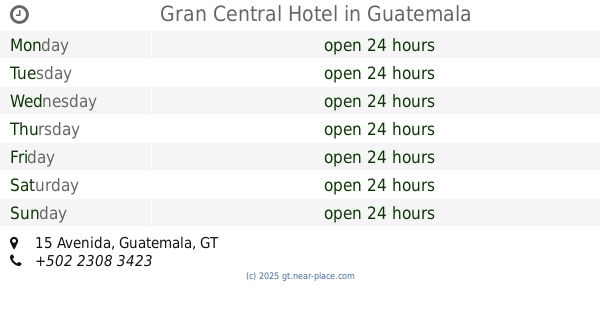
Gran Central Hotel
9 25, 15 Avenida, Guatemala
Lodging
read more
645 m
Hotel Casa Washigton
Guatemala
Lodging
read more
649 m
Antiguo Hotel Fenix
Guatemala
Lodging
read more
656 m
Hotel Ajau
Guatemala City
Lodging
read more
675 m
Hotel Belmund Zona 1 Guatemala
Guatemala City
Lodging
read more
676 m
Asociación Católica "Amor y Acción", ACAYA
Centro Histórico de Guatemala, Guatemala
Lodging
read more
691 m
Hotel Casa De Los Nazarenos
5A Calle 3-36, Guatemala
Lodging
read more
801 m
Tienda Mario
Centro Histórico de
Lodging
read more
818 m
Hotel Torino
9A Calle A, Guatemala
Lodging
read more
880 m
Hostal Rocio B&B
5 avenida 3 A calle zona 1 5-19, Guatemala
Lodging
read more
1.006 km
Hotel Villa Florentina
13, 3 Calle 5-53, Guatemala
Lodging
read more
1.02 km
Hotel Montecarlo
9 avenida 16-20 zona 1, Guatemala
Lodging
read more
1.135 km
Hotel La Roca
Guatemala City
Lodging
read more
1.213 km
Auto hotel la cascada
Guatemala
Lodging
read more
📑
all categories
Accounting
Administrative area level 1
Administrative area level 2
Airport
Amusement park
Aquarium
Art gallery
Atm
Bakery
Bank
Bar
Beauty salon
Bicycle store
Book store
Bowling alley
Bus station
Cafe
Campground
Car dealer
Car rental
Car repair
Car wash
Casino
Cemetery
Church
City hall
Clothing store
Colloquial area
Convenience store
Courthouse
Dentist
Department store
Doctor
Electrician
Electronics store
Embassy
Establishment
Finance
Fire station
Florist
Food
Funeral home
Furniture store
Gas station
General contractor
Grocery or supermarket
Gym
Hair care
Hardware store
Health
Hindu Temple
Home goods store
Hospital
Insurance agency
Jewelry store
Laundry
Lawyer
Library
Liquor store
Local government office
Locality
Locksmith
Lodging
Meal delivery
Meal takeaway
Mosque
Movie rental
Movie theater
Moving company
Museum
Natural feature
Neighborhood
Night club
Painter
Park
Parking
Pet store
Pharmacy
Physiotherapist
Place of worship
Plumber
Point of interest
Police
Political
Post office
Premise
Real estate agency
Restaurant
Route
Rv park, camping
School
Shoe store
Shopping mall
Spa
Stadium
Storage
Store
Subway station
Supermarket
Synagogue
Taxi stand
Train station
Transit station
Travel agency
University
Veterinary care
Zoo
administrative area level 3
sublocality level 1
↑