Lodging nearby Hotel Villa Libertad
Guatemala
Lodging nearby Hotel Villa Libertad
Hotel Villa Libertad
Flores Guatemala
contacts phone
:
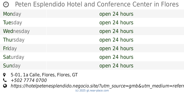
+502
Latitude:
16.9198508
, Longitude:
-89.8981687
read more
nearest Lodging
352 m
Hotel Posada Santander
Flores
Lodging
read more
463 m
Hotel Tayasal
Calle limite, Flores
Lodging
read more
561 m
Hospedaje Ixchel
Flores
Lodging
read more
579 m
Hotel Gardenias
Flores
Lodging
read more
622 m
Hotel Jaguar Inn
Tikal National Park, Flores
Lodging
read more
630 m
Hotel Y Restaurante Clasico Petin
1, Flores
Lodging
read more
651 m
Hotel Continental
Flores
Lodging
read more
693 m
Maximos Petit Hotel
1 Avenida zona 1 Santa Elena Peten, Flores, 17001
Lodging
Point of interest
Establishment
read more
708 m
Hotel Villa Los Arcos
Flores
Lodging
read more
716 m
Hotel Casa Flores de Tikal
6a Avenida, Flores
Lodging
read more
722 m
HOTEL EXPRESS BY MAYA INN
Flores
Lodging
read more
731 m
Hotel Patio Grande
Flores
Lodging
read more
736 m
Peten Esplendido Hotel and Conference Center
1a Calle 5-01, Flores
Lodging
Point of interest
Establishment
read more
793 m
Hotel Cali
San Benito
Lodging
read more
843 m
Hotel La Casa del Estudiante
Barrio la Ermita zona1 a la par del parque way O enfrente de la clinica de los riñones uronorte San Benito
Lodging
Point of interest
Establishment
read more
865 m
Hotel Ave Indiana
7a Avenida, Flores
Lodging
read more
917 m
Hotel Del Patio-Tikal
6a Avenida 1-15, Flores
Lodging
read more
917 m
Hotel Del Patio
6a Avenida 1-15, Flores
Lodging
read more
921 m
Hotel Del Patio
2a Calle, Flores
Lodging
read more
1.102 km
Hotel Santana
Calle 30 de junio playa poniente, isla de, Flores
Lodging
read more
1.122 km
Green World Hotel
Calle 30 de Junio, Flores
Lodging
read more
1.13 km
Hotel Santa Rita
Flores
Lodging
read more
1.198 km
Flores de Peten Hotel Y Restaurante
Flores
Lodging
read more
1.229 km
Hotel Casablanca
Flores
Lodging
read more
1.289 km
Auto Hotel Guacamaya
Flores
Lodging
read more
📑
all categories
Accounting
Administrative area level 1
Administrative area level 2
Airport
Amusement park
Aquarium
Art gallery
Atm
Bakery
Bank
Bar
Beauty salon
Bicycle store
Book store
Bowling alley
Bus station
Cafe
Campground
Car dealer
Car rental
Car repair
Car wash
Casino
Cemetery
Church
City hall
Clothing store
Colloquial area
Convenience store
Courthouse
Dentist
Department store
Doctor
Electrician
Electronics store
Embassy
Establishment
Finance
Fire station
Florist
Food
Funeral home
Furniture store
Gas station
General contractor
Grocery or supermarket
Gym
Hair care
Hardware store
Health
Hindu Temple
Home goods store
Hospital
Insurance agency
Jewelry store
Laundry
Lawyer
Library
Liquor store
Local government office
Locality
Locksmith
Lodging
Meal delivery
Meal takeaway
Mosque
Movie rental
Movie theater
Moving company
Museum
Natural feature
Neighborhood
Night club
Painter
Park
Parking
Pet store
Pharmacy
Physiotherapist
Place of worship
Plumber
Point of interest
Police
Political
Post office
Premise
Real estate agency
Restaurant
Route
Rv park, camping
School
Shoe store
Shopping mall
Spa
Stadium
Storage
Store
Subway station
Supermarket
Synagogue
Taxi stand
Train station
Transit station
Travel agency
University
Veterinary care
Zoo
administrative area level 3
sublocality level 1
↑