Lodging nearby Hotel Texas
Guatemala
Lodging nearby Hotel Texas
Hotel Texas
Escuintla, Guatemala
contacts phone
:
+502 7888 0183
Latitude:
14.2931865
, Longitude:
-90.7826455
larger map & directions
read more
nearest Lodging
76 m
HOTEL SARITA
Escuintla
Lodging
read more
586 m
Hotel Costa Sur
Escuintla
Lodging
read more
871 m
IGT ESCUINTLA
Guatemala
Lodging
read more
941 m
Hotel Francelia
Escuintla
Lodging
read more
1.05 km
Hotel La villa
Escuintla
Lodging
read more
1.099 km
Anexo Madrid
Unnamed Road
Lodging
read more
1.213 km
Hospedaje La Ronda
2-37, 6 Avenida 1, Guatemala
Lodging
read more
1.213 km
Hospedaje La Ronda
2-37 6 Avenida 1
Lodging
read more
1.262 km
palmeras del norte
1 4-35d, 5 Calle, Escuintla
Lodging
read more
1.332 km
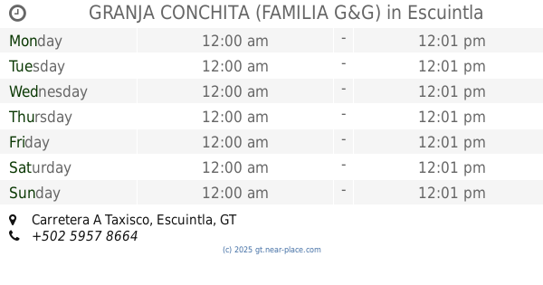
GRANJA CONCHITA (FAMILIA G&G)
kilómetro 60.50, Carretera A Taxisco, Escuintla
Lodging
read more
1.343 km
La Villa Hotel
hotel la villa
Lodging
read more
1.356 km
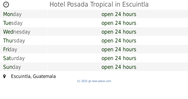
Hotel Posada Tropical
Escuintla
Lodging
read more
1.367 km
Hotel y Restaurante la Villa
Escuintla
Lodging
read more
1.388 km
Hotel La Colmena
Escuintla
Lodging
read more
1.388 km
Hospedaje La Colmena
4 calle 1-66, Escuintla
Lodging
read more
1.391 km
Hotel La Villa
3a. Calle, Escuintla
Lodging
read more
2.14 km
Motel Escuintla
Kilómetro 61, Carretera A Taxisco, motel
Lodging
read more
2.498 km
Auto Hotel Deluxe
Escuintla
Lodging
read more
2.514 km
Hotel Arizona
av. 3 calle. Lote 229, zona 3, Escuintla
Lodging
read more
2.554 km
AutoHotel Monterrey
Escuintla
Lodging
read more
2.567 km
Auto Hotel Hay Wey
Escuintla
Lodging
read more
3.078 km
La Puti Casa
Escuintla
Lodging
read more
3.094 km
Grupo Pacto 24 Alcoholicos Anonimos
Escuintla
Lodging
read more
4.16 km
Hidro Santa Elena
Guatemala
Lodging
read more
11.612 km
AutoHotel El Mirador
Guatemala
Lodging
read more
📑
all categories
Accounting
Administrative area level 1
Administrative area level 2
Airport
Amusement park
Aquarium
Art gallery
Atm
Bakery
Bank
Bar
Beauty salon
Bicycle store
Book store
Bowling alley
Bus station
Cafe
Campground
Car dealer
Car rental
Car repair
Car wash
Casino
Cemetery
Church
City hall
Clothing store
Colloquial area
Convenience store
Courthouse
Dentist
Department store
Doctor
Electrician
Electronics store
Embassy
Establishment
Finance
Fire station
Florist
Food
Funeral home
Furniture store
Gas station
General contractor
Grocery or supermarket
Gym
Hair care
Hardware store
Health
Hindu Temple
Home goods store
Hospital
Insurance agency
Jewelry store
Laundry
Lawyer
Library
Liquor store
Local government office
Locality
Locksmith
Lodging
Meal delivery
Meal takeaway
Mosque
Movie rental
Movie theater
Moving company
Museum
Natural feature
Neighborhood
Night club
Painter
Park
Parking
Pet store
Pharmacy
Physiotherapist
Place of worship
Plumber
Point of interest
Police
Political
Post office
Premise
Real estate agency
Restaurant
Route
Rv park, camping
School
Shoe store
Shopping mall
Spa
Stadium
Storage
Store
Subway station
Supermarket
Synagogue
Taxi stand
Train station
Transit station
Travel agency
University
Veterinary care
Zoo
administrative area level 3
sublocality level 1
↑