Local government office nearby Municipalidad De San Pablo Jocopilas, Suchitepequez
Coronavirus disease (COVID-19) Situation
confirmed cases
1291293
deaths
20289
Guatemala
Local government office nearby Municipalidad De San Pablo Jocopilas, Suchitepequez
Municipalidad De San Pablo Jocopilas, Suchitepequez
San Pablo Jocopilas Guatemala
contacts phone
:
+502
Latitude:
14.5871604
, Longitude:
-91.45376
read more
nearest Local government office
4.949 km
Sub Estacion PNC
2a Avenida, San Bernardino
Local government office
read more
7.211 km
Fondo de Tierras, Mazatenango
5ta. Avenida Diagonal 1 0-78 Zona 1, Mazatenango
Local government office
read more
7.322 km
Maycom
Mazatenango
Local government office
read more
7.975 km
Municipalidad de Mazatenango
Palacio Municipalidad de Mazatenango, Mazatenango
Local government office
read more
8.022 km
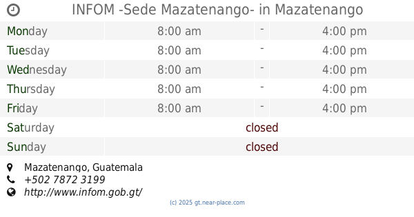
INFOM -Sede Mazatenango-
Mazatenango
Local government office
read more
8.952 km
Delegación Contraloria General de Cuentas
CA-2, Mazatenango
Local government office
read more
11.568 km
Terminal De Buses San Felipe
Pueblo Nuevo
Local government office
read more
12.736 km
Municipalidad Del Nuevo Palmar
4 Calle
Local government office
read more
12.922 km
Municipality of San Lorenzo
San Lorenzo
Local government office
read more
12.922 km
Municipalidad de San Lorenzo
San Lorenzo
Local government office
read more
14.582 km
Municipalidad De Chicacao Suchitepuez
Chicacao
Local government office
read more
16.672 km
PNC San Martin Zapotitlan
San Martín Zapotitlán
Local government office
read more
16.675 km
RENAP
San Martín Zapotitlán
Local government office
read more
19.916 km
Auxiliatura Municipal Montecristo
Santa María Visitación
Local government office
read more
21.568 km
Centro de Atención Permanente
14, San Juan La Laguna
Local government office
read more
23.874 km
Sede MAGA Retalhulue
Retalhuleu
Local government office
read more
24.759 km
Contraloria General de Cuentas
6a Calle, Retalhuleu
Local government office
read more
24.759 km
Auditor General
6a Calle, Retalhuleu
Local government office
read more
24.808 km
Oficina AAPOSA
Santiago Atitlán
Local government office
read more
24.825 km
Empresa Electrica Municipal de Retalhuleu
5a Calle, Retalhuleu
Local government office
read more
24.913 km
Municipalidad de Cantel
Cantel
Local government office
read more
24.913 km
Municipality of Cantel
Cantel
Local government office
read more
25.692 km
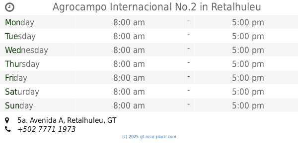
Agrocampo Internacional No.2
5a. Avenida A, Retalhuleu
Local government office
read more
28.707 km
MUNICIPALIDAD
Santa Lucía Utatlán
Local government office
read more
59.181 km
Palacio de Gobernacion Departamental
Santa Cruz del Quiché
Local government office
read more
📑
all categories
Accounting
Administrative area level 1
Administrative area level 2
Airport
Amusement park
Aquarium
Art gallery
Atm
Bakery
Bank
Bar
Beauty salon
Bicycle store
Book store
Bowling alley
Bus station
Cafe
Campground
Car dealer
Car rental
Car repair
Car wash
Casino
Cemetery
Church
City hall
Clothing store
Colloquial area
Convenience store
Courthouse
Dentist
Department store
Doctor
Electrician
Electronics store
Embassy
Establishment
Finance
Fire station
Florist
Food
Funeral home
Furniture store
Gas station
General contractor
Grocery or supermarket
Gym
Hair care
Hardware store
Health
Hindu Temple
Home goods store
Hospital
Insurance agency
Jewelry store
Laundry
Lawyer
Library
Liquor store
Local government office
Locality
Locksmith
Lodging
Meal delivery
Meal takeaway
Mosque
Movie rental
Movie theater
Moving company
Museum
Natural feature
Neighborhood
Night club
Painter
Park
Parking
Pet store
Pharmacy
Physiotherapist
Place of worship
Plumber
Point of interest
Police
Political
Post office
Premise
Real estate agency
Restaurant
Route
Rv park, camping
School
Shoe store
Shopping mall
Spa
Stadium
Storage
Store
Subway station
Supermarket
Synagogue
Taxi stand
Train station
Transit station
Travel agency
University
Veterinary care
Zoo
administrative area level 3
sublocality level 1
↑