Gym nearby Estadio J. Octavio Barillas
Guatemala
Gym nearby Estadio J. Octavio Barillas
Estadio J. Octavio Barillas
La Unión Guatemala
contacts phone
:
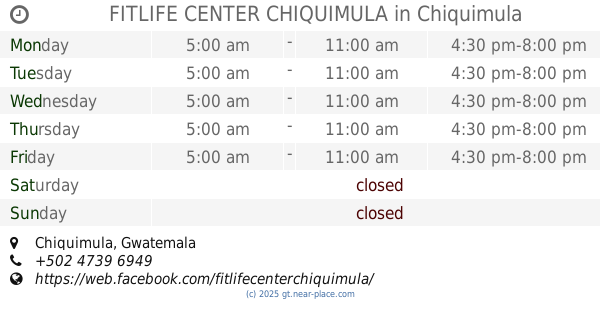
+502
Latitude:
14.9618478
, Longitude:
-89.2966386
read more
nearest Gym
115 m
Polideportivo Kevin Cordon
La Unión
Gym
read more
15.665 km
Campo de Futbol /Cajon Del Río
Chiquimula
Gym
read more
18.185 km
PERFEC BODY GYM "Para Verte y Sentirte Bien"
Calle Principal Camotan, Camotán
Gym
read more
18.63 km
Olimpia Municipal Stadium
Jocotan
Gym
read more
23.071 km
Estadio De Futbol
Jumuzna
Gym
read more
24.57 km
Estadio de Futball
Aldea, Santa Rosalía
Gym
read more
24.681 km
Taurus GYM
Zacapa
Gym
read more
30.314 km
Sport Gym
Estanzuela
Gym
read more
30.665 km
Area Deportiva CDAG —Pista De Motocross
Chiquimula
Gym
read more
30.919 km
FITLIFE CENTER CHIQUIMULA
Chiquimula
Gym
read more
31.834 km
Sportlife Chiquimula
8 20 2, 7a. Avenida Zona 1, Chiquimula
Gym
read more
32.548 km
Instituto Nacional De Bosques
Chiquimula
Gym
read more
32.749 km
Deportito Sport GYM
Chiquimula
Gym
read more
33.711 km
Gimnasio El Molino
Chiquimula
Gym
read more
39.241 km
OXY GYM CRUZ ESPAÑA
4 CALLE 4-12 ZONA 1 BARRIO SANTA BARBARA, Quezaltepeque Chiquimula
Gym
read more
44.226 km
Barrio Nuevo ZUMBA
Esquipulas
Gym
read more
44.651 km
Zumba Esquipulas
2da. Avenida, Esquipulas
Gym
read more
44.656 km
Cancha Cemercan
Esquipulas
Gym
read more
44.716 km
UltraGym
Esquipulas
Gym
read more
44.725 km
Gimnasio Colegio San Benito
Bulevar San Benito, Esquipulas
Gym
read more
44.824 km
XELAJU GYM
9na. CALLE 0-45 ZONA 4 ESQUIPULAS CHIQUIMULA, Esquipulas
Gym
read more
51.765 km
Concepcion Las Minas
Concepción Las Minas
Gym
read more
51.989 km
Gimnasio SOTO.
Concepción Las Minas
Gym
read more
62.275 km
Centro Turístico RAXHA
Guatemala
Gym
read more
62.275 km
RAXHA Touristic center
Guatemala
Gym
read more
📑
all categories
Accounting
Administrative area level 1
Administrative area level 2
Airport
Amusement park
Aquarium
Art gallery
Atm
Bakery
Bank
Bar
Beauty salon
Bicycle store
Book store
Bowling alley
Bus station
Cafe
Campground
Car dealer
Car rental
Car repair
Car wash
Casino
Cemetery
Church
City hall
Clothing store
Colloquial area
Convenience store
Courthouse
Dentist
Department store
Doctor
Electrician
Electronics store
Embassy
Establishment
Finance
Fire station
Florist
Food
Funeral home
Furniture store
Gas station
General contractor
Grocery or supermarket
Gym
Hair care
Hardware store
Health
Hindu Temple
Home goods store
Hospital
Insurance agency
Jewelry store
Laundry
Lawyer
Library
Liquor store
Local government office
Locality
Locksmith
Lodging
Meal delivery
Meal takeaway
Mosque
Movie rental
Movie theater
Moving company
Museum
Natural feature
Neighborhood
Night club
Painter
Park
Parking
Pet store
Pharmacy
Physiotherapist
Place of worship
Plumber
Point of interest
Police
Political
Post office
Premise
Real estate agency
Restaurant
Route
Rv park, camping
School
Shoe store
Shopping mall
Spa
Stadium
Storage
Store
Subway station
Supermarket
Synagogue
Taxi stand
Train station
Transit station
Travel agency
University
Veterinary care
Zoo
administrative area level 3
sublocality level 1
↑