Gym nearby Cancha Deportivo Santiagito
Guatemala
Gym nearby Cancha Deportivo Santiagito
Cancha Deportivo Santiagito
Guatemala Guatemala
contacts phone
:
+502
Latitude:
14.467038
, Longitude:
-91.3418448
read more
nearest Gym
9.011 km
Complejo Deportivo / Picinas/
Chicacao
Gym
read more
11.497 km
Gimnasio Municipal
2a. Av. y 2a. calle zona 1, San Antonio Suchitepéquez
Gym
read more
18.7 km
MegaGym Mazatenango
Bajada del Corinto,, 8a Calle, Mazatenango
Gym
read more
18.799 km
Revivel Gym
7A Avenida 4-77, Mazatenango
Gym
read more
18.82 km
El Club De Nutricion
Mazatenango
Gym
read more
19.105 km
Barberia Santos
Plaza Américas, Mazatenango
Gym
read more
19.417 km
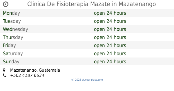
Clinica De Fisioterapia Mazate
Mazatenango
Gym
read more
19.474 km
Canchas CampNow
Santo Tomás La Unión
Gym
read more
19.71 km
POWERGYM FITNESS CLUB
Santo Tomás La Unión
Gym
read more
19.926 km
Futbolandia
Mazatenango
Gym
read more
19.926 km
Futigol
Mazatenango
Gym
read more
23.805 km
Gimnasio Municipal
San Francisco Zapotitlán
Gym
read more
26.075 km
San Pedro Gym
San Pedro La Laguna
Gym
read more
26.093 km
Gym La Mano De Dios
6A Avenida 07018, San Pedro La Laguna
Gym
read more
26.104 km
Cuyutenango Suchitepequez
Cuyotenango
Gym
read more
26.264 km
Gimnasio Municipal, San Pedro La Laguna
San Pedro La Laguna
Gym
read more
28.185 km
PONCHOS GYM
San Lucas Tolimán
Gym
read more
30.422 km
Silver Gym
El Nuevo Palmar
Gym
read more
34.631 km
PALOPÓ FITNESS GYM
Barrio Tzanimabey, San Antonio Palopó
Gym
read more
39.227 km
Paseo Royal Canchas Sinteticas
Retalhuleu
Gym
read more
45.968 km
GYM IMUA FITNESS HNOS GUZMAN
Quetzaltenango
Gym
read more
46.03 km
Shanti Yoga
Unnamed Road
Gym
read more
46.74 km
Herbalife
9 calle 24-38, Quezaltenango
Gym
read more
48.986 km
BODY GYM
Carretera a chiyax, Totonicapán
Gym
read more
49.538 km
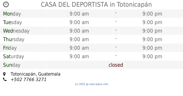
CASA DEL DEPORTISTA
Totonicapán
Gym
read more
📑
all categories
Accounting
Administrative area level 1
Administrative area level 2
Airport
Amusement park
Aquarium
Art gallery
Atm
Bakery
Bank
Bar
Beauty salon
Bicycle store
Book store
Bowling alley
Bus station
Cafe
Campground
Car dealer
Car rental
Car repair
Car wash
Casino
Cemetery
Church
City hall
Clothing store
Colloquial area
Convenience store
Courthouse
Dentist
Department store
Doctor
Electrician
Electronics store
Embassy
Establishment
Finance
Fire station
Florist
Food
Funeral home
Furniture store
Gas station
General contractor
Grocery or supermarket
Gym
Hair care
Hardware store
Health
Hindu Temple
Home goods store
Hospital
Insurance agency
Jewelry store
Laundry
Lawyer
Library
Liquor store
Local government office
Locality
Locksmith
Lodging
Meal delivery
Meal takeaway
Mosque
Movie rental
Movie theater
Moving company
Museum
Natural feature
Neighborhood
Night club
Painter
Park
Parking
Pet store
Pharmacy
Physiotherapist
Place of worship
Plumber
Point of interest
Police
Political
Post office
Premise
Real estate agency
Restaurant
Route
Rv park, camping
School
Shoe store
Shopping mall
Spa
Stadium
Storage
Store
Subway station
Supermarket
Synagogue
Taxi stand
Train station
Transit station
Travel agency
University
Veterinary care
Zoo
administrative area level 3
sublocality level 1
↑