Gym nearby Cancha Cintetica
Coronavirus disease (COVID-19) Situation
confirmed cases
1291293
deaths
20289
Guatemala
Gym nearby Cancha Cintetica
Cancha Cintetica
6ta Avenida, Rabinal Guatemala
contacts phone
:
+502
Latitude:
15.08126
, Longitude:
-90.4879033
read more
nearest Gym
751 m
Gym FITNESS CLUB
2da. ave. 2-43, Rabinal
Gym
read more
17.921 km
Villa Deportiva
Salamá
Gym
read more
18.076 km
Gimnasio Pineda
Salamá
Gym
read more
19.06 km
Gimnasio Salud Y Fuerza
Salamá
Gym
read more
19.701 km
Cancha de Usos Multiples CDAG
Granados
Gym
read more
20.8 km
Gimnasio MyM
Baja Verapaz
Gym
read more
25.672 km
Energim
Pachalum
Gym
read more
30.349 km
Luigino Fitness
10 Avenida, Tactic
Gym
read more
46.835 km
Fields of Alameda
Guatemala City
Gym
read more
46.892 km
Expofitness San Martin
San Martín Jilotepeque
Gym
read more
47.137 km
Campo tiro guatemala
Guatemala City
Gym
read more
47.144 km
Centro Deportivo La Plancha
Col, 1 De Julio, Guatemala
Gym
read more
47.425 km
Apartamentos PRIMIUM 2
B, 13 Avenida, Guatemala
Gym
read more
47.858 km
Gimnasio Fitness Extreme
Guatemala City
Gym
read more
47.858 km
Campau Zumba Studio
bulevar el caminero 11-95, zona 6 de, Mixco
Gym
read more
48.229 km
Futeca Sport GYM El Naranjo
Naranjo Mall, Zona 4 de Mixco, Condado Naranjo Mixco, Guatemala 1057
Gym
read more
48.285 km
Scandinavia Gym Metro Norte Zona 17
Calzada Mariscal Zavala 00-92 11 Avenida Plaza Nororiente Anxeo Centro Comercial MetroNorte, Guatemala
Gym
read more
48.643 km
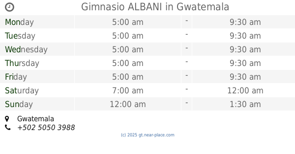
Gimnasio ALBANI
Guatemala City
Gym
read more
49.037 km
Gimnasio Smart Training
Guatemala City Historical District, Guatemala City
Gym
read more
49.631 km
Super Weidder
13 Avenida, Guatemala
Gym
read more
49.912 km
Gimnasio Life & Soul
0 9—89 1, 4 calle, Guatemala
Gym
read more
50.015 km
Orellanos Kempo Karate
33 Avenida 11-85, Guatemala
Gym
read more
51.838 km
Gimnasio Municipal
Guastatoya
Gym
read more
54.609 km
Canchas de Papifutbol "Las Majadas"
Sumpango
Gym
read more
59.723 km
Hércules Gym Chimaltenangon II
Chimaltenango
Gym
read more
📑
all categories
Accounting
Administrative area level 1
Administrative area level 2
Airport
Amusement park
Aquarium
Art gallery
Atm
Bakery
Bank
Bar
Beauty salon
Bicycle store
Book store
Bowling alley
Bus station
Cafe
Campground
Car dealer
Car rental
Car repair
Car wash
Casino
Cemetery
Church
City hall
Clothing store
Colloquial area
Convenience store
Courthouse
Dentist
Department store
Doctor
Electrician
Electronics store
Embassy
Establishment
Finance
Fire station
Florist
Food
Funeral home
Furniture store
Gas station
General contractor
Grocery or supermarket
Gym
Hair care
Hardware store
Health
Hindu Temple
Home goods store
Hospital
Insurance agency
Jewelry store
Laundry
Lawyer
Library
Liquor store
Local government office
Locality
Locksmith
Lodging
Meal delivery
Meal takeaway
Mosque
Movie rental
Movie theater
Moving company
Museum
Natural feature
Neighborhood
Night club
Painter
Park
Parking
Pet store
Pharmacy
Physiotherapist
Place of worship
Plumber
Point of interest
Police
Political
Post office
Premise
Real estate agency
Restaurant
Route
Rv park, camping
School
Shoe store
Shopping mall
Spa
Stadium
Storage
Store
Subway station
Supermarket
Synagogue
Taxi stand
Train station
Transit station
Travel agency
University
Veterinary care
Zoo
administrative area level 3
sublocality level 1
↑