Gym nearby Campo De Football Mario Alioto
Guatemala
Gym nearby Campo De Football Mario Alioto
Campo De Football Mario Alioto
15 Avenida, Guatemala, GT Gwatemala
contacts phone
:
+502
Latitude:
14.5038221
, Longitude:
-90.5849784
larger map & directions
read more
nearest Gym
462 m
poli deportivo la pilona
4-59 6, 1 Calle, Villa Nueva
Gym
read more
528 m
Gimnasio Municipal Mario Alioto
Villa Nueva
Gym
read more
535 m
Reformers gym and park.
Villa Nueva
Gym
read more
1.45 km
Cancha Polideportiva De Grama Sintética Ciudad Del Sol
Villa Nueva
Gym
read more
1.652 km
Gimnasio Canchas Ciudad Del Sol
2 Avenida, Villa Nueva
Gym
read more
1.746 km
Equinox Gym
Villa Nueva
Gym
read more
1.888 km
I Love Fitness
1 avenida 3calle zona 5 Villa Nueva centro comercial el tabacal segundo nivel local, 44
Gym
read more
2.059 km
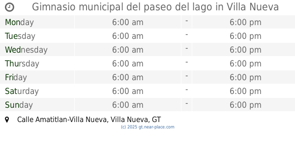
Gimnasio municipal del paseo del lago
Calle Amatitlan-Villa Nueva, Villa Nueva
Gym
read more
2.08 km
Gimnasio Area Sport
0 Avenida, Guatemala
Gym
read more
2.649 km
Gimnasio Colegio Guatemala de la Asunción
3 Avenida 5-53, Villa Nueva
Gym
read more
2.747 km
Gimnasio Municipal Cd. Villa Nueva
Villa Nueva
Gym
read more
2.861 km
CAMPOS DE FUT SANTA IZABEL VILLA NUEVA
Unnamed Road
Gym
read more
3.277 km
Gimnasio Municipal
5 Avenida, Villa Nueva
Gym
read more
3.492 km
Gotcha AMATITLÁN
Amatitlán
Gym
read more
3.7 km
Altos de Fuentes 3
Guatemala
Gym
read more
4.159 km
Equinox Villa Hermosa
Guatemala
Gym
read more
4.179 km
Canchas De Futbol La Vuelta
Guatemala
Gym
read more
4.31 km
Gran Sauce
Unnamed Rd,
Gym
read more
4.397 km
Fitness Factory
Carretera CA-9
Gym
read more
4.408 km
Campo De Futbol El BUCARO
Villa Nueva
Gym
read more
4.834 km
Gym Mar Paz
Amatitlán
Gym
read more
5.196 km
Iron Gym
Calle Real de Petapa
Gym
read more
5.522 km
Gimnasio Energym
4-33, 4 Avenida, Amatitlán
Gym
read more
5.744 km
schumann's Villa Canales
Guatemala
Gym
read more
6.007 km
Campo De Football Barcena
Villa Nueva
Gym
read more
📑
all categories
Accounting
Administrative area level 1
Administrative area level 2
Airport
Amusement park
Aquarium
Art gallery
Atm
Bakery
Bank
Bar
Beauty salon
Bicycle store
Book store
Bowling alley
Bus station
Cafe
Campground
Car dealer
Car rental
Car repair
Car wash
Casino
Cemetery
Church
City hall
Clothing store
Colloquial area
Convenience store
Courthouse
Dentist
Department store
Doctor
Electrician
Electronics store
Embassy
Establishment
Finance
Fire station
Florist
Food
Funeral home
Furniture store
Gas station
General contractor
Grocery or supermarket
Gym
Hair care
Hardware store
Health
Hindu Temple
Home goods store
Hospital
Insurance agency
Jewelry store
Laundry
Lawyer
Library
Liquor store
Local government office
Locality
Locksmith
Lodging
Meal delivery
Meal takeaway
Mosque
Movie rental
Movie theater
Moving company
Museum
Natural feature
Neighborhood
Night club
Painter
Park
Parking
Pet store
Pharmacy
Physiotherapist
Place of worship
Plumber
Point of interest
Police
Political
Post office
Premise
Real estate agency
Restaurant
Route
Rv park, camping
School
Shoe store
Shopping mall
Spa
Stadium
Storage
Store
Subway station
Supermarket
Synagogue
Taxi stand
Train station
Transit station
Travel agency
University
Veterinary care
Zoo
administrative area level 3
sublocality level 1
↑