Funeral home nearby Funerales Galindo
Guatemala
Funeral home nearby Funerales Galindo
Funerales Galindo
Retalhuleu, Guatemala
contacts phone
:
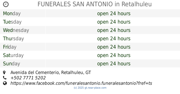
+502 7771 0285
Latitude:
14.5390884
, Longitude:
-91.6790789
larger map & directions
read more
nearest Funeral home
190 m
Funerales Gallito
Retalhuleu
Funeral home
read more
226 m
Funeraria Retalhuleu
7a Calle 1-32, Retalhuleu
Funeral home
read more
330 m
Funerales Flores
4a Calle, Retalhuleu
Funeral home
read more
366 m
FUNERALES SAN ANTONIO
9-10 CANTON SAN JOSESITO, Avenida del Cementerio, Retalhuleu
Funeral home
read more
18.76 km
Funeraria La Cruz
Mazatenango
Funeral home
read more
26.652 km
Funerales Coatepeque
Coatepeque
Funeral home
read more
36.802 km
Funerales Quetzaltenango
10a Calle, Quezaltenango
Funeral home
read more
36.958 km
Funerales Quetzaltenango
Quezaltenango
Funeral home
read more
36.958 km
Funerales Quetzaltenango
Quetzaltenango
Funeral home
read more
37.101 km
Funerales Reforma
6ta Calle 7-05 Zona 1, Quezaltenango
Funeral home
read more
37.257 km
Capillas Señoriales Quetzaltenango
Quetzaltenango
Funeral home
read more
37.257 km
Capillas Señoriales Quetzaltenango
Quezaltenango
Funeral home
read more
37.607 km
Funerales La Trinidad
Quetzaltenango
Funeral home
read more
37.607 km
Funerales La Trinidad
Quezaltenango
Funeral home
read more
37.771 km
Funerales Minerva
Quetzaltenango
Funeral home
read more
37.771 km
Funerales Minerva
Quezaltenango
Funeral home
read more
38.429 km
Del Angel
Quezaltenango
Funeral home
read more
38.429 km
Del Angel
Quetzaltenango
Funeral home
read more
49.15 km
Funerales Auxiliadora
San Cristóbal Totonicapán
Funeral home
read more
49.413 km
Funerales Gloria
9a. Calle, San Marcos
Funeral home
read more
49.421 km
FUNERALES GLORIA
9A Calle 14-135, San Marcos
Funeral home
read more
58.056 km
Capillas y Funerales El Cedro
Malacatán
Funeral home
read more
📑
all categories
Accounting
Administrative area level 1
Administrative area level 2
Airport
Amusement park
Aquarium
Art gallery
Atm
Bakery
Bank
Bar
Beauty salon
Bicycle store
Book store
Bowling alley
Bus station
Cafe
Campground
Car dealer
Car rental
Car repair
Car wash
Casino
Cemetery
Church
City hall
Clothing store
Colloquial area
Convenience store
Courthouse
Dentist
Department store
Doctor
Electrician
Electronics store
Embassy
Establishment
Finance
Fire station
Florist
Food
Funeral home
Furniture store
Gas station
General contractor
Grocery or supermarket
Gym
Hair care
Hardware store
Health
Hindu Temple
Home goods store
Hospital
Insurance agency
Jewelry store
Laundry
Lawyer
Library
Liquor store
Local government office
Locality
Locksmith
Lodging
Meal delivery
Meal takeaway
Mosque
Movie rental
Movie theater
Moving company
Museum
Natural feature
Neighborhood
Night club
Painter
Park
Parking
Pet store
Pharmacy
Physiotherapist
Place of worship
Plumber
Point of interest
Police
Political
Post office
Premise
Real estate agency
Restaurant
Route
Rv park, camping
School
Shoe store
Shopping mall
Spa
Stadium
Storage
Store
Subway station
Supermarket
Synagogue
Taxi stand
Train station
Transit station
Travel agency
University
Veterinary care
Zoo
administrative area level 3
sublocality level 1
↑