Food nearby restaurante La Cojunda
Guatemala
Food nearby restaurante La Cojunda
restaurante La Cojunda
Q2HQ+W2R, San Juan de Dios, Guatemala
contacts phone
:
+502
Latitude:
16.779869
, Longitude:
-89.9624709
larger map & directions
read more
nearest Food
2.144 km
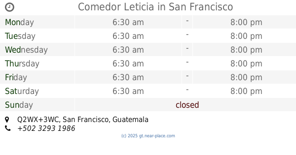
Comedor Leticia
Q2WX+3WC, San Francisco
Restaurant
Food
Point of interest
Establishment
read more
3.291 km
Nolascos Bar&Grill
Unnamed Road
Restaurant
Food
Point of interest
Establishment
read more
3.538 km
Taqueria El Cuate
Unnamed Road
Cafe
Food
Point of interest
Store
Establishment
read more
3.563 km
Pollo Feliz
Q3W8+2QX, San Francisco
Restaurant
Food
Point of interest
Establishment
read more
3.565 km
Super Ahorro
Q3W8+7M4, San Francisco
Supermarket
Grocery or supermarket
Food
Point of interest
Store
Establishment
read more
3.623 km
Pollolandia
Q3W8+CRM, San Francisco
Restaurant
Food
Point of interest
Establishment
read more
3.675 km
Super Jireh
Barrio el Paraiso, San Francisco
Supermarket
Grocery or supermarket
Food
Point of interest
Store
Establishment
read more
3.696 km
Super El Paraíso
Unnamed Road
Supermarket
Grocery or supermarket
Food
Point of interest
Store
Establishment
read more
3.741 km
SUPER TIENDA EL AHORRO
BARRIO CONCORDIA, San Francisco
Supermarket
Grocery or supermarket
Food
Point of interest
Store
Establishment
read more
3.741 km
TACOS Y ANTOJITOS MAYA
San Juan de Dios, San Francisco, Peten San Francisco, Peten
Restaurant
Food
Point of interest
Establishment
read more
3.936 km
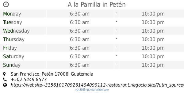
A la Parrilla
San Francisco, Petén
Restaurant
Food
Point of interest
Establishment
read more
3.939 km
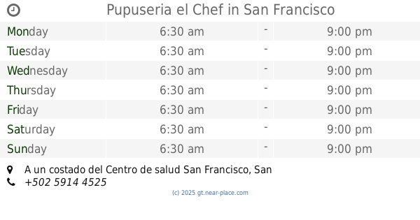
Pupuseria el Chef
A un costado del Centro de salud San Francisco
Restaurant
Food
Point of interest
Establishment
read more
3.973 km
Comedor San Pancho
Q3X9+HM6, San Francisco
Restaurant
Food
Point of interest
Establishment
read more
4.264 km
Comedor Maya Azteca
R32C+R38, San Francisco
Restaurant
Food
Point of interest
Establishment
read more
5.45 km
Restaurante El Corral
R37F+HQ2, San Francisco
Restaurant
Food
Point of interest
Establishment
read more
10.379 km
Hacienda San Vicente
San Francisco Peten
Campground
Lodging
Park
Restaurant
Food
Point of interest
Establishment
read more
14.523 km
Agroveterinaria Vicente
Unnamed Road, Santa Ana
Supermarket
Grocery or supermarket
Food
Point of interest
Store
Establishment
read more
14.763 km
SUPREMA
RD-PET-11, San Benito
Supermarket
Grocery or supermarket
Food
Point of interest
Store
Establishment
read more
15.423 km
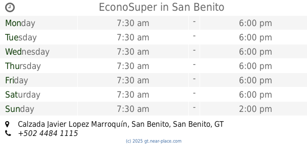
EconoSuper
Calzada Javier Lopez Marroquín, San Benito
Supermarket
Grocery or supermarket
Food
Point of interest
Store
Establishment
read more
15.644 km
Bodega San Benito Peten
San Benito
Food
read more
15.891 km
Supermercado La Casita
Flores
Supermarket
Grocery or supermarket
Food
Point of interest
Store
Establishment
read more
15.913 km
Abarroteria mary
8a Calle, San Benito
Supermarket
Grocery or supermarket
Food
Point of interest
Store
Establishment
read more
16.52 km
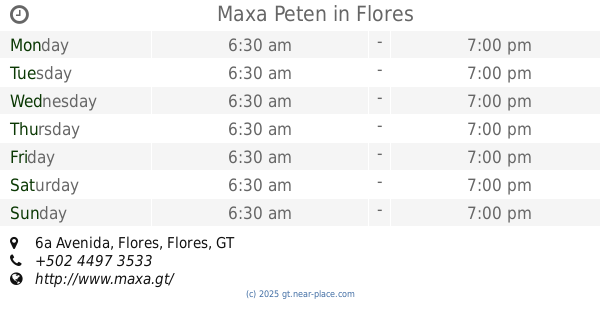
Maxa Peten
6a Avenida, Flores
Supermarket
Grocery or supermarket
Food
Point of interest
Store
Establishment
read more
16.56 km
El Pinol
W475+443, Flores
Cafe
Food
Point of interest
Establishment
read more
16.602 km
Despensa Familiar
6a Avenida, Flores
Supermarket
Grocery or supermarket
Food
Point of interest
Store
Establishment
read more
📑
all categories
Accounting
Administrative area level 1
Administrative area level 2
Airport
Amusement park
Aquarium
Art gallery
Atm
Bakery
Bank
Bar
Beauty salon
Bicycle store
Book store
Bowling alley
Bus station
Cafe
Campground
Car dealer
Car rental
Car repair
Car wash
Casino
Cemetery
Church
City hall
Clothing store
Colloquial area
Convenience store
Courthouse
Dentist
Department store
Doctor
Electrician
Electronics store
Embassy
Establishment
Finance
Fire station
Florist
Food
Funeral home
Furniture store
Gas station
General contractor
Grocery or supermarket
Gym
Hair care
Hardware store
Health
Hindu Temple
Home goods store
Hospital
Insurance agency
Jewelry store
Laundry
Lawyer
Library
Liquor store
Local government office
Locality
Locksmith
Lodging
Meal delivery
Meal takeaway
Mosque
Movie rental
Movie theater
Moving company
Museum
Natural feature
Neighborhood
Night club
Painter
Park
Parking
Pet store
Pharmacy
Physiotherapist
Place of worship
Plumber
Point of interest
Police
Political
Post office
Premise
Real estate agency
Restaurant
Route
Rv park, camping
School
Shoe store
Shopping mall
Spa
Stadium
Storage
Store
Subway station
Supermarket
Synagogue
Taxi stand
Train station
Transit station
Travel agency
University
Veterinary care
Zoo
administrative area level 3
sublocality level 1
↑