Cemetery nearby PET VET MADAGASCAR
Guatemala
Cemetery nearby PET VET MADAGASCAR
PET VET MADAGASCAR
33 Ave. 8-07 Z. 7, Col Jardines De Tikal 2, Guatemala Guatemala
contacts phone
:
+502
Latitude:
14.6345022
, Longitude:
-90.5580439
read more
nearest Cemetery
1.425 km
Cementerio de Mascotas Los Rosales
Calzada San Juan 8-50, Guatemala
Cemetery
read more
1.935 km
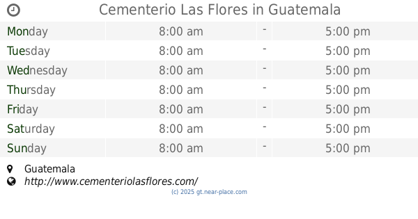
Cementerio Las Flores
Interamerican Highway, Guatemala
Cemetery
read more
2.007 km
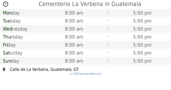
Cementerio La Verbena
Calle de La Verbena, Guatemala
Cemetery
read more
2.231 km
Cementerio La Verbena
Zona 7
Cemetery
read more
3.026 km
Mausoleo
Guatemala City
Cemetery
read more
3.026 km
Mausoleo
Guatemala
Cemetery
read more
3.358 km
Cementerio General
Guatemala City
Cemetery
read more
3.393 km
Interior Cementerio General
y, Avenida del Cementerio & 22 Calle, Guatemala
Cemetery
read more
3.393 km
Interior Cementerio General
y, Avenida del Cementerio, Guatemala
Cemetery
read more
4.469 km
Cementerio Jardines de la Paz
Guatemala
Cemetery
read more
4.469 km
Cementerio Jardines de la Paz
Guatemala City
Cemetery
read more
4.711 km
Cemetery Garden of Brother Pedro
16 Avenida Lote K52, Colonia Nimajay Zona 7, Mixco
Cemetery
read more
4.733 km
Cementerio de Mixco
Guatemala
Cemetery
read more
4.733 km
Cementerio de Mixco
Guatemala City
Cemetery
read more
4.749 km
Cementerio
Guatemala-Stadt
Cemetery
read more
4.811 km
Cementerio Municipal De Mixco
Guatemala City
Cemetery
read more
4.811 km
Cementerio Municipal De Mixco
Guatemala
Cemetery
read more
5.079 km
Descanza Baby Yankee
Guatemala City
Cemetery
read more
5.187 km
Cementerio Las Flores
Guatemala
Cemetery
read more
6.763 km
Cementerio La Colina
Unnamed Road
Cemetery
read more
8.123 km
Las Buganvilias
Guatemala City
Cemetery
read more
10.428 km
Cementerio los Caracoles
Guatemala
Cemetery
read more
13.283 km
Cementerio Municipal
Guatamala City
Cemetery
read more
13.818 km
Cementerio Cristo Rey
Cemetery
read more
16.298 km
Cementerio Municipal Magdalena Milpas Altas
Gwatemala
Cemetery
read more
📑
all categories
Accounting
Administrative area level 1
Administrative area level 2
Airport
Amusement park
Aquarium
Art gallery
Atm
Bakery
Bank
Bar
Beauty salon
Bicycle store
Book store
Bowling alley
Bus station
Cafe
Campground
Car dealer
Car rental
Car repair
Car wash
Casino
Cemetery
Church
City hall
Clothing store
Colloquial area
Convenience store
Courthouse
Dentist
Department store
Doctor
Electrician
Electronics store
Embassy
Establishment
Finance
Fire station
Florist
Food
Funeral home
Furniture store
Gas station
General contractor
Grocery or supermarket
Gym
Hair care
Hardware store
Health
Hindu Temple
Home goods store
Hospital
Insurance agency
Jewelry store
Laundry
Lawyer
Library
Liquor store
Local government office
Locality
Locksmith
Lodging
Meal delivery
Meal takeaway
Mosque
Movie rental
Movie theater
Moving company
Museum
Natural feature
Neighborhood
Night club
Painter
Park
Parking
Pet store
Pharmacy
Physiotherapist
Place of worship
Plumber
Point of interest
Police
Political
Post office
Premise
Real estate agency
Restaurant
Route
Rv park, camping
School
Shoe store
Shopping mall
Spa
Stadium
Storage
Store
Subway station
Supermarket
Synagogue
Taxi stand
Train station
Transit station
Travel agency
University
Veterinary care
Zoo
administrative area level 3
sublocality level 1
↑