Cemetery nearby Cementerio
Guatemala
Cemetery nearby Cementerio
Cementerio
La Gomera, Guatemala
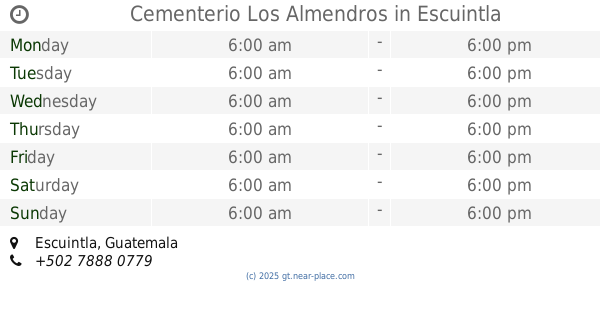
contacts phone
:
+502
Latitude:
14.0853262
, Longitude:
-91.0527778
larger map & directions
read more
nearest Cemetery
1.261 km
Cementerio General No. 3
La Gomera
Cemetery
read more
19.446 km
Cementerio General
La Democracia
Cemetery
read more
25.371 km
Cementerio General Siquinalá
Siquinala
Cemetery
read more
27.674 km
Cementerio General
Santa Lucía Cotzumalguapa
Cemetery
read more
27.702 km
Cemetery
Santa Lucía Cotzumalguapa
Cemetery
read more
30.193 km
Cementerio De Santa lucia Cotz
a 5-32 Esc., 1ra. Avenida, Santa Lucía Cotzumalguapa
Cemetery
read more
36.376 km
Cementerio Los Almendros
Escuintla
Cemetery
read more
36.667 km
Cementerio General, Escuintla.
Cementerio General, Escuintla
Cemetery
read more
36.67 km
Cementerio General
Escuintla
Cemetery
read more
37.477 km
Cementerio Las Orquideas
Escuintla
Cemetery
read more
47.323 km
Cementerio Municipal
11, San Pedro Yepocapa
Cemetery
read more
51.176 km
Cementerio Municipal de Palín, Escuintla, Guatemala
Palín
Cemetery
read more
51.975 km
Cementerio
Alotenango
Cemetery
read more
54.894 km
Cementerio San Miguel Dueñas
Guatemala
Cemetery
read more
56.692 km
Cementerio de Ciudad Vieja
Ciudad Vieja
Cemetery
read more
56.794 km
Cementerio General De Ciudad Vieja
Ciudad Vieja
Cemetery
read more
57.802 km
Cementerio General San Vicente
Guatemala
Cemetery
read more
58.149 km
Cementerio Municipal
Volcan de Agua, Santa Maria de Jesús
Cemetery
read more
60.039 km
cementerio municipal los olivos
San Miguel Panán
Cemetery
read more
63.296 km
Cementerio General
Amatitlán
Cemetery
read more
63.31 km
Cementerio General De Amatitlan
Amatitlán
Cemetery
read more
63.32 km
Cementerio Jardines de PAmpichin
Amatitlán
Cemetery
read more
64.161 km
Cementerio Municipal de Santo Domingo
Gwatemala
Cemetery
read more
64.161 km
Cementerio Municipal de Santo Domingo
Guatemala
Cemetery
read more
70.407 km
Cementerio General
Mazatenango
Cemetery
read more
📑
all categories
Accounting
Administrative area level 1
Administrative area level 2
Airport
Amusement park
Aquarium
Art gallery
Atm
Bakery
Bank
Bar
Beauty salon
Bicycle store
Book store
Bowling alley
Bus station
Cafe
Campground
Car dealer
Car rental
Car repair
Car wash
Casino
Cemetery
Church
City hall
Clothing store
Colloquial area
Convenience store
Courthouse
Dentist
Department store
Doctor
Electrician
Electronics store
Embassy
Establishment
Finance
Fire station
Florist
Food
Funeral home
Furniture store
Gas station
General contractor
Grocery or supermarket
Gym
Hair care
Hardware store
Health
Hindu Temple
Home goods store
Hospital
Insurance agency
Jewelry store
Laundry
Lawyer
Library
Liquor store
Local government office
Locality
Locksmith
Lodging
Meal delivery
Meal takeaway
Mosque
Movie rental
Movie theater
Moving company
Museum
Natural feature
Neighborhood
Night club
Painter
Park
Parking
Pet store
Pharmacy
Physiotherapist
Place of worship
Plumber
Point of interest
Police
Political
Post office
Premise
Real estate agency
Restaurant
Route
Rv park, camping
School
Shoe store
Shopping mall
Spa
Stadium
Storage
Store
Subway station
Supermarket
Synagogue
Taxi stand
Train station
Transit station
Travel agency
University
Veterinary care
Zoo
administrative area level 3
sublocality level 1
↑