Cemetery nearby Cementario
Guatemala
Cemetery nearby Cementario
Cementario
San Rafael Pie de la Cuesta Guatemala
contacts phone
:
+502
Latitude:
14.929707
, Longitude:
-91.9176336
read more
nearest Cemetery
3.718 km
cementerio de EL PORVENIR
Guatemala
Cemetery
read more
7.788 km
El Tumbador
El Tumbador
Cemetery
read more
9.435 km
Cementerio
Esquipulas Palo Gordo
Cemetery
read more
10.549 km
Cementerio Aldea Tánil
Guatemala
Cemetery
read more
11.859 km
Cementerio De La Lima
La Lima Malacatan
Cemetery
read more
13.037 km
Cementerio General
San Marcos
Cemetery
read more
13.047 km
Cementerio General, San Francisco Soche
Avenida Petapa 91, Guatemala
Cemetery
read more
13.135 km
Cementerio De San Marcos
San Marcos
Cemetery
read more
14.068 km
Cementerio
San Marcos
Cemetery
read more
14.444 km
Cementerio
San Cristóbal Cucho
Cemetery
read more
15.208 km
Cementerio General San Pedro Sacatepequez
San Pedro Sacatepequez
Cemetery
read more
15.246 km
Cementerio De San Pedro Sacatepequez
San Pedro Sacatepequez
Cemetery
read more
15.355 km
Cementerio
Aldea Champollap
Cemetery
read more
16.008 km
Cementerio Municipal Malacatán
Malacatán
Cemetery
read more
17.256 km
Cementerio de San Sebastian, San Marcos
Guatemala
Cemetery
read more
17.444 km
Cementerio de Chamac
Chamac
Cemetery
read more
18.011 km
Cementerio
La Reforma
Cemetery
read more
19.952 km
Cementerio General
San Antonio Sacatepéquez
Cemetery
read more
21.039 km
Cementerio De Champacche
Guatemala
Cemetery
read more
24.078 km
Cementerio
Tejutla
Cemetery
read more
24.099 km
Cementerio General De Tejutla
Unnamed Road, Tejutla
Cemetery
read more
24.154 km
CEMENTERIO GENERAL DE LA CIENAGA
Caserío La Ciénaga, San Lorenzo
Cemetery
read more
24.394 km
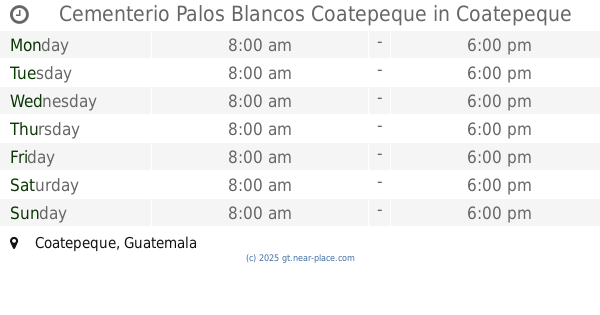
Cementerio Palos Blancos Coatepeque
Coatepeque
Cemetery
read more
24.467 km
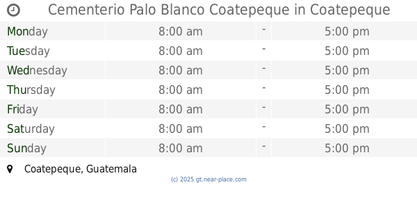
Cementerio Palo Blanco Coatepeque
Coatepeque
Cemetery
read more
26.423 km
Cementerio
Pajapita
Cemetery
read more
📑
all categories
Accounting
Administrative area level 1
Administrative area level 2
Airport
Amusement park
Aquarium
Art gallery
Atm
Bakery
Bank
Bar
Beauty salon
Bicycle store
Book store
Bowling alley
Bus station
Cafe
Campground
Car dealer
Car rental
Car repair
Car wash
Casino
Cemetery
Church
City hall
Clothing store
Colloquial area
Convenience store
Courthouse
Dentist
Department store
Doctor
Electrician
Electronics store
Embassy
Establishment
Finance
Fire station
Florist
Food
Funeral home
Furniture store
Gas station
General contractor
Grocery or supermarket
Gym
Hair care
Hardware store
Health
Hindu Temple
Home goods store
Hospital
Insurance agency
Jewelry store
Laundry
Lawyer
Library
Liquor store
Local government office
Locality
Locksmith
Lodging
Meal delivery
Meal takeaway
Mosque
Movie rental
Movie theater
Moving company
Museum
Natural feature
Neighborhood
Night club
Painter
Park
Parking
Pet store
Pharmacy
Physiotherapist
Place of worship
Plumber
Point of interest
Police
Political
Post office
Premise
Real estate agency
Restaurant
Route
Rv park, camping
School
Shoe store
Shopping mall
Spa
Stadium
Storage
Store
Subway station
Supermarket
Synagogue
Taxi stand
Train station
Transit station
Travel agency
University
Veterinary care
Zoo
administrative area level 3
sublocality level 1
↑