Cafe nearby Coffee Tefis Bakery
Guatemala
Cafe nearby Coffee Tefis Bakery
Coffee Tefis Bakery
Sanarate Guatemala
contacts phone
:
+502
Latitude:
14.7863096
, Longitude:
-90.1977837
read more
nearest Cafe
1.749 km
La Tertulia Crepas Y Cafe
Sanarate
Cafe
read more
4.747 km
Comedor Diana
CA-9N, Agua Salóbrega
Cafe
read more
9.683 km
Piňateria De Todo Un Poco
Sansare
Cafe
read more
9.763 km
Cafeteria y comedor el Cafetalito
Sansare
Cafe
read more
10.018 km
Cafetería M & M
San Antonio la Paz
Cafe
read more
15.006 km
Irtra
Irtra Agua Caliente, Agua Caliente
Cafe
read more
15.781 km
Café La Antigua
Calle Principal, Guastatoya
Cafe
read more
20.711 km
CAFETERÍA EMANUEL
Calle Principal Colinas del Norte, 14°43'38.6"N 90°22'50.0"W, Guatemala
Cafe
read more
24.297 km
Lo de Silva
Guatemala
Cafe
read more
25.047 km
El Rancho
El Progreso
Cafe
read more
28.008 km
Pan y Cafe
Jalapa
Cafe
read more
28.107 km
El Patio, Cafe, Bar And Grill
Jalapa
Cafe
read more
28.216 km
WillySnow
Jalapa
Cafe
read more
28.835 km
Cafe Villa Del Rio
CA-19, Jalapa
Cafe
read more
28.857 km
El Viejo Cafe
Jalapa
Cafe
read more
29.21 km
MENTHA
Unnamed Road
Cafe
read more
37.725 km
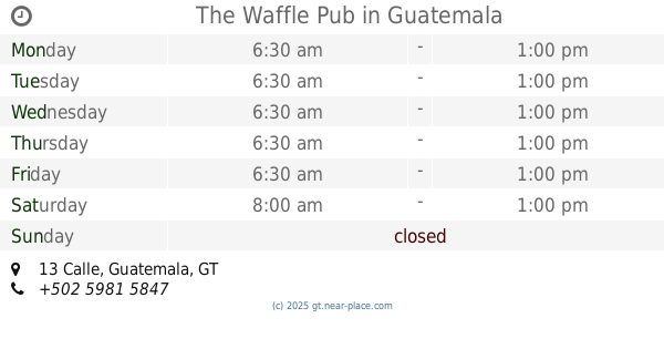
The Waffle Pub
13 Calle, Guatemala
Cafe
read more
37.772 km
Café Tasso Hadjidudou
11 Calle, Ciudad de Guatemala
Cafe
Food
Point of interest
Establishment
read more
38.57 km
Mio Café
JFCP+XCV, Guatemala City
Cafe
Food
Point of interest
Establishment
read more
39.557 km
De La Cami
Guatemala City
Cafe
read more
42.459 km
Café Gitane
Guatemala City
Cafe
read more
42.608 km
Pausas Bar
Colonia Mariscal, Guatemala
Cafe
read more
44.558 km
Gitane Cafe
Guatemala
Cafe
read more
45.372 km
Pupuseria Las Obejitas
Colonia Las Brisas, Guatemala
Cafe
read more
53.001 km
Wifi Cafe
San Lucas Sacatepéquez
Cafe
read more
📑
all categories
Accounting
Administrative area level 1
Administrative area level 2
Airport
Amusement park
Aquarium
Art gallery
Atm
Bakery
Bank
Bar
Beauty salon
Bicycle store
Book store
Bowling alley
Bus station
Cafe
Campground
Car dealer
Car rental
Car repair
Car wash
Casino
Cemetery
Church
City hall
Clothing store
Colloquial area
Convenience store
Courthouse
Dentist
Department store
Doctor
Electrician
Electronics store
Embassy
Establishment
Finance
Fire station
Florist
Food
Funeral home
Furniture store
Gas station
General contractor
Grocery or supermarket
Gym
Hair care
Hardware store
Health
Hindu Temple
Home goods store
Hospital
Insurance agency
Jewelry store
Laundry
Lawyer
Library
Liquor store
Local government office
Locality
Locksmith
Lodging
Meal delivery
Meal takeaway
Mosque
Movie rental
Movie theater
Moving company
Museum
Natural feature
Neighborhood
Night club
Painter
Park
Parking
Pet store
Pharmacy
Physiotherapist
Place of worship
Plumber
Point of interest
Police
Political
Post office
Premise
Real estate agency
Restaurant
Route
Rv park, camping
School
Shoe store
Shopping mall
Spa
Stadium
Storage
Store
Subway station
Supermarket
Synagogue
Taxi stand
Train station
Transit station
Travel agency
University
Veterinary care
Zoo
administrative area level 3
sublocality level 1
↑