Cafe nearby Casa Nativos
Guatemala
Cafe nearby Casa Nativos
Casa Nativos
13 Avenida, 09001, Quezaltenango, GT Guatemala
contacts phone
:
+502 4726 2582
Latitude:
14.8348384
, Longitude:
-91.5189658
larger map & directions
read more
nearest Cafe
33 m
CAFE BELICE
Quezaltenango
Cafe
read more
147 m
El Cuartito
13ave 7-09, Quezaltenango
Cafe
read more
147 m
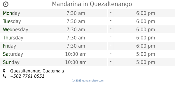
Mandarina
Quezaltenango
Cafe
read more
219 m
Frutopía
6a Calle 9-30 Zona 1, Quezaltenango
Cafe
read more
232 m
Heladeria Italiana Abby
15- 1, 4a Calle 22-40, Quezaltenango
Cafe
read more
237 m
Casa Moba
3 calle 14a-40, Quezaltenango
Cafe
read more
244 m
La Vienesa
Quezaltenango
Cafe
read more
260 m
La Cafetera
8a Calle, Quezaltenango
Cafe
read more
264 m
Básico Coffee Co.
2a Calle, Quezaltenango
Cafe
read more
265 m
Utopía Club
7ma calle 15 - 42 zona 1, Quezaltenango
Cafe
read more
271 m
Milenios Cafe
Quezaltenango
Cafe
read more
286 m
Miel Y Café
2a Calle 15-42, Quezaltenango
Cafe
Food
Point of interest
Establishment
read more
303 m
Bonita Café_Bar
15 Avenida A 2-33, Quezaltenango
Cafe
Food
Point of interest
Store
Establishment
read more
333 m
Beer zone
1a Calle - Calle Cajola, Quezaltenango
Cafe
read more
341 m
Vision.net
9a Calle, Quezaltenango
Cafe
read more
362 m
Leos Café Bar
6a Calle, Quezaltenango
Cafe
read more
463 m
Jugocity
1a Calle - Calle Cajola, Quezaltenango
Cafe
read more
499 m
Helados Roca
8a Calle, Quezaltenango
Cafe
read more
724 m
Cafeteria Luna de Xelaju
16 Avenida B 0-57, Quezaltenango
Cafe
read more
751 m
Notorio's Gastrocafé
Quetzaltenango
Cafe
read more
783 m
The Hideaway
Quetzaltenango
Cafe
read more
797 m
La Vienesa Jesus Castillo
Avenida Jesus Castillo, Quezaltenango
Cafe
read more
1.009 km
XELA COFFEE
21 Avenida, Quezaltenango
Cafe
read more
1.013 km
De 10
Quetzaltenango
Cafe
read more
1.031 km
Cafe Utz Ulew Mall
19 ave, 229
Cafe
read more
📑
all categories
Accounting
Administrative area level 1
Administrative area level 2
Airport
Amusement park
Aquarium
Art gallery
Atm
Bakery
Bank
Bar
Beauty salon
Bicycle store
Book store
Bowling alley
Bus station
Cafe
Campground
Car dealer
Car rental
Car repair
Car wash
Casino
Cemetery
Church
City hall
Clothing store
Colloquial area
Convenience store
Courthouse
Dentist
Department store
Doctor
Electrician
Electronics store
Embassy
Establishment
Finance
Fire station
Florist
Food
Funeral home
Furniture store
Gas station
General contractor
Grocery or supermarket
Gym
Hair care
Hardware store
Health
Hindu Temple
Home goods store
Hospital
Insurance agency
Jewelry store
Laundry
Lawyer
Library
Liquor store
Local government office
Locality
Locksmith
Lodging
Meal delivery
Meal takeaway
Mosque
Movie rental
Movie theater
Moving company
Museum
Natural feature
Neighborhood
Night club
Painter
Park
Parking
Pet store
Pharmacy
Physiotherapist
Place of worship
Plumber
Point of interest
Police
Political
Post office
Premise
Real estate agency
Restaurant
Route
Rv park, camping
School
Shoe store
Shopping mall
Spa
Stadium
Storage
Store
Subway station
Supermarket
Synagogue
Taxi stand
Train station
Transit station
Travel agency
University
Veterinary care
Zoo
administrative area level 3
sublocality level 1
↑