Cafe nearby Cafeteria El Mana
Coronavirus disease (COVID-19) Situation
confirmed cases
1291293
deaths
20289
Guatemala
Cafe nearby Cafeteria El Mana
Cafeteria El Mana
04 av 03 - 75 Zona 1, San Pedro Necta Guatemala
contacts phone
:
+502
Latitude:
15.4913692
, Longitude:
-91.7646662
read more
nearest Cafe
5.958 km
Finca Miralvalle, Agua Dulce, Sn Pedro Necta, Huehuetgo.
San Pedro Necta
Cafe
read more
6.318 km
Finca Vista Hermosa
Guatemala
Cafe
read more
8.379 km
El Cable, Huehuetenango, Guatemala
Cafe
read more
17.93 km
Cafe El Mirador
San Antonio Huista
Cafe
read more
17.951 km
Cafe Huistlan
San Antonio Huista
Cafe
read more
20.225 km
CAFÉ ANGELITA
Jacaltenango
Cafe
read more
20.428 km
El Cafe De La Cuadra
Ruta Las cruces, Jacaltenango
Cafe
read more
22.676 km
Siver Internet
Lupiná
Cafe
read more
26.572 km
El Portal Café Y Restaurante
km 334, caserío Marilandia, La Democracia
Cafe
read more
27.305 km
Flor Del Café
Cuilco
Cafe
read more
29.082 km
Cafeteria El Azador.
Huehuetenango
Cafe
read more
34.592 km
Cafetería Y Asados Soliz
Unnamed Road, Huehuetenango
Cafe
read more
34.925 km
Lochita's Snacks
Huehuetenango
Cafe
read more
35.491 km
Cafeteria EL CHEF
Huehuetenango
Cafe
read more
35.919 km
Caceta Desayunos Almuerzos
Huehuetenango
Cafe
read more
36.094 km
Cafeteria Don Lupe
Chiantla
Cafe
read more
36.398 km
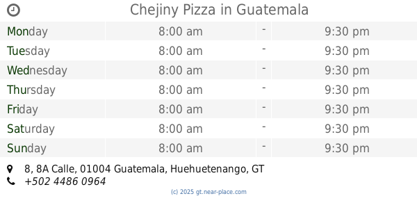
Chejiny Pizza
B 28 5, 8A Calle 8, Guatemala
Cafe
read more
36.64 km
Urbano´s Cafe Internet
4a Calle, Huehuetenango
Cafe
read more
36.677 km
Bejucos
6-30, 6a Avenida 2a Calle, Huehuetenango
Cafe
read more
36.683 km
Café Museo
4ta. calle 7-40, Huehuetenango
Cafe
read more
36.726 km
Pupuseria La Unica
Huehuetenango
Cafe
read more
36.848 km
Es Mas Que Café
Huehuetenango
Cafe
read more
40.549 km
Panaderia "San Cristobal"
Ixchiguan
Cafe
read more
51.386 km
WEB.NET EN AGUACATAN
7W, Aguacatán
Cafe
read more
59.634 km
Cafetería Mia
Totonicapán
Cafe
read more
📑
all categories
Accounting
Administrative area level 1
Administrative area level 2
Airport
Amusement park
Aquarium
Art gallery
Atm
Bakery
Bank
Bar
Beauty salon
Bicycle store
Book store
Bowling alley
Bus station
Cafe
Campground
Car dealer
Car rental
Car repair
Car wash
Casino
Cemetery
Church
City hall
Clothing store
Colloquial area
Convenience store
Courthouse
Dentist
Department store
Doctor
Electrician
Electronics store
Embassy
Establishment
Finance
Fire station
Florist
Food
Funeral home
Furniture store
Gas station
General contractor
Grocery or supermarket
Gym
Hair care
Hardware store
Health
Hindu Temple
Home goods store
Hospital
Insurance agency
Jewelry store
Laundry
Lawyer
Library
Liquor store
Local government office
Locality
Locksmith
Lodging
Meal delivery
Meal takeaway
Mosque
Movie rental
Movie theater
Moving company
Museum
Natural feature
Neighborhood
Night club
Painter
Park
Parking
Pet store
Pharmacy
Physiotherapist
Place of worship
Plumber
Point of interest
Police
Political
Post office
Premise
Real estate agency
Restaurant
Route
Rv park, camping
School
Shoe store
Shopping mall
Spa
Stadium
Storage
Store
Subway station
Supermarket
Synagogue
Taxi stand
Train station
Transit station
Travel agency
University
Veterinary care
Zoo
administrative area level 3
sublocality level 1
↑