Bar nearby Ozy Resto Bar y Discotec
Guatemala
Bar nearby Ozy Resto Bar y Discotec
Ozy Resto Bar y Discotec
Jalapa Gwatemala
contacts phone
:
+502
Latitude:
14.6390167
, Longitude:
-89.9949958
read more
nearest Bar
719 m
El Pete Gonzales
Jalapa
Bar
read more
1.296 km
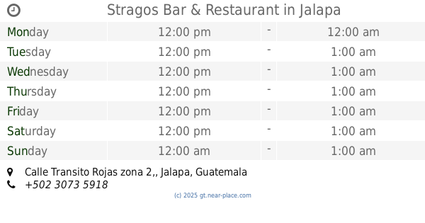
Stragos Bar & Restaurant
Calle Transito Rojas zona 2,
Bar
read more
1.3 km
Food And Drink
RN-18, Jalapa
Bar
read more
1.47 km
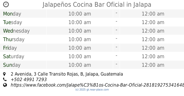
Jalapeños Cocina Bar Oficial
2 Avenida, 3 Calle Transito Rojas, B
Bar
read more
2.326 km
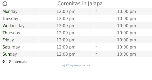
Coronitas
Guatemala
Bar
read more
20.916 km
Rancho Linda Vista
Monjas
Bar
read more
24.29 km
Vinícola Casillero Santiago
Mataquescuintla
Bar
read more
26.022 km
Stragos
Guastatoya
Bar
read more
40.618 km
Mandala Cafe Bar
7ma calle, Jutiapa
Bar
read more
41.971 km
El Ocaso
San José Pinula
Bar
read more
47.907 km
Night Club Panamericano
Asunción Mita
Bar
read more
48.958 km
Cantina LA CEIBITA
Interamerican Highway, Tiucal
Bar
read more
50.517 km
Tertulias Café Bar & Lounge
00-11 5, 3 Avenida, Chiquimula
Bar
read more
50.532 km
Bar El Pime
Unnamed Road
Bar
read more
50.812 km
la bodeguita sport bar
5-73 1, 2 Avenida, Chiquimula
Bar
read more
50.848 km
LA BODEGUITA
Chiquimula
Bar
read more
50.851 km
Cantina Doña Carmelina
2a. Avenida, Chiquimula
Bar
read more
51.171 km
Poncho Sport Bar
3 Avenida colonia El Caminero Zona 4, Chiquimula
Bar
read more
51.196 km
Kenkes Bar
5a. Calle, Chiquimula
Bar
read more
51.552 km
Los Tarros, Snak´s Bar
Barrio Sasmó Arriba
Bar
read more
51.613 km
Cantina La Central
2a Calle, Chiquimula
Bar
read more
51.833 km
Buhos Longe
Cuilapa
Bar
read more
52.092 km
Mayarlin
Colonia El Milagro, 10a. Avenida, Chiquimula
Bar
read more
53.687 km
Rancho Los Primos
23, Yupiltepeque
Bar
read more
62.076 km
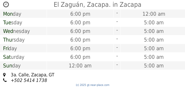
El Zaguán, Zacapa.
3a. Calle, Zacapa
Bar
read more
📑
all categories
Accounting
Administrative area level 1
Administrative area level 2
Airport
Amusement park
Aquarium
Art gallery
Atm
Bakery
Bank
Bar
Beauty salon
Bicycle store
Book store
Bowling alley
Bus station
Cafe
Campground
Car dealer
Car rental
Car repair
Car wash
Casino
Cemetery
Church
City hall
Clothing store
Colloquial area
Convenience store
Courthouse
Dentist
Department store
Doctor
Electrician
Electronics store
Embassy
Establishment
Finance
Fire station
Florist
Food
Funeral home
Furniture store
Gas station
General contractor
Grocery or supermarket
Gym
Hair care
Hardware store
Health
Hindu Temple
Home goods store
Hospital
Insurance agency
Jewelry store
Laundry
Lawyer
Library
Liquor store
Local government office
Locality
Locksmith
Lodging
Meal delivery
Meal takeaway
Mosque
Movie rental
Movie theater
Moving company
Museum
Natural feature
Neighborhood
Night club
Painter
Park
Parking
Pet store
Pharmacy
Physiotherapist
Place of worship
Plumber
Point of interest
Police
Political
Post office
Premise
Real estate agency
Restaurant
Route
Rv park, camping
School
Shoe store
Shopping mall
Spa
Stadium
Storage
Store
Subway station
Supermarket
Synagogue
Taxi stand
Train station
Transit station
Travel agency
University
Veterinary care
Zoo
administrative area level 3
sublocality level 1
↑