Bakery nearby Pastelería Los Tulipanes
Coronavirus disease (COVID-19) Situation
confirmed cases
1291293
deaths
20289
Guatemala
Bakery nearby Pastelería Los Tulipanes
Pastelería Los Tulipanes
Centro Comercial Santa Amelia, Blvd. Centro Medico Militar, Guatemala Guatemala
contacts phone
:
+502
Latitude:
14.6255499
, Longitude:
-90.4727916
read more
nearest Bakery
621 m
CAKE DESIGN
Guatemala City
Bakery
read more
621 m
CAKE DESIGN
Guatemala
Bakery
read more
707 m
Panaderia Pavallier
0 Calle, Guatemala
Bakery
read more
2.276 km
Panadería Le Fournil
Guatemala City
Bakery
read more
2.276 km
Panadería Le Fournil
Guatemala
Bakery
read more
2.329 km
Le Petit Paris
Guatemala City
Bakery
read more
2.329 km
Le Petit Paris
Guatemala
Bakery
read more
2.349 km
Anfora
20 Calle, Guatemala
Bakery
read more
2.389 km
Isopan
20 Calle, Guatemala
Bakery
read more
2.476 km
Pasteleria Patsy
Carretera al atlántico Zona 17, Metro Norte KM 5, Guatemala
Bakery
read more
2.484 km
Pastelería Los Tulipanes
Paseo Cayalá - Edificio B1, Bulevar Rafael Landivar, Guatemala
Bakery
read more
2.505 km
Pasteleria Anfora
Metro Norte, Guatemala
Bakery
read more
2.52 km
Pasteleria Milano
Km. 5 Carretera al Atlántico, Ciudad de Guatemala
Bakery
Cafe
Food
Point of interest
Store
Establishment
read more
2.781 km
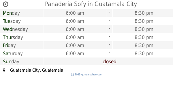
Panaderia Sofy
Guatemala City
Bakery
read more
2.781 km
Panaderia Sofy
Guatemala
Bakery
read more
2.795 km
Panaderia Iso Pan
Guatemala City
Bakery
read more
2.795 km
Panaderia Iso Pan
Guatemala
Bakery
read more
2.798 km
Pasteleria Ciro
Guatemala
Bakery
read more
2.798 km
Pasteleria Ciro
Guatemala City
Bakery
read more
2.958 km
Boutique Pastel
Residenciales San Gaspar zona, 16, Guatemala
Bakery
read more
3.036 km
MASEIN
11 Calle, Guatemala
Bakery
read more
3.548 km
Pan Corona
Guatemala
Bakery
read more
3.548 km
Pan Corona
Guatemala City
Bakery
read more
3.863 km
Pan Pavalier
3 Av. 4-17 Z.2, 16 Avenida 2-65, 6, Guatemala
Bakery
read more
4.915 km
Panaderia Olid
13 Avenida 14-83, Diagonal 6, Guatemala
Bakery
read more
📑
all categories
Accounting
Administrative area level 1
Administrative area level 2
Airport
Amusement park
Aquarium
Art gallery
Atm
Bakery
Bank
Bar
Beauty salon
Bicycle store
Book store
Bowling alley
Bus station
Cafe
Campground
Car dealer
Car rental
Car repair
Car wash
Casino
Cemetery
Church
City hall
Clothing store
Colloquial area
Convenience store
Courthouse
Dentist
Department store
Doctor
Electrician
Electronics store
Embassy
Establishment
Finance
Fire station
Florist
Food
Funeral home
Furniture store
Gas station
General contractor
Grocery or supermarket
Gym
Hair care
Hardware store
Health
Hindu Temple
Home goods store
Hospital
Insurance agency
Jewelry store
Laundry
Lawyer
Library
Liquor store
Local government office
Locality
Locksmith
Lodging
Meal delivery
Meal takeaway
Mosque
Movie rental
Movie theater
Moving company
Museum
Natural feature
Neighborhood
Night club
Painter
Park
Parking
Pet store
Pharmacy
Physiotherapist
Place of worship
Plumber
Point of interest
Police
Political
Post office
Premise
Real estate agency
Restaurant
Route
Rv park, camping
School
Shoe store
Shopping mall
Spa
Stadium
Storage
Store
Subway station
Supermarket
Synagogue
Taxi stand
Train station
Transit station
Travel agency
University
Veterinary care
Zoo
administrative area level 3
sublocality level 1
↑